Want to Create Your Own 3D Printed Topographical Map? It’s Surprisingly Easy

 For many people, the use of maps has been reduced to chatty, often obnoxious GPS applications, and while I’ve gotten lost far less often with my GPS than I ever did with a paper map and set of written instructions, there’s something about an old-fashioned map that people still seem to love and miss. I have a severely underdeveloped sense of direction and am hopeless at reading maps in any kind of useful way, but I still like to look at them, especially when they’re mounted prettily on a wall and not tangled up in my glove compartment after another failed refolding attempt.
There’s an artistry to maps, and thankfully it’s still appreciated by many who are unwilling to let the art form disappear altogether. In fact, while technology has made the paper map rather obsolete, technology has also presented new ways to design and display beautiful maps – particularly topographical ones. 3D printing has excited many a map nerd, and a lot of incredible 3D printed maps have come to our attention – just look at the work of Eric Pavey, for instance.
It’s easy to look in amazement at the work created by someone like Pavey and think “I could never do that.” Not true – there are actually numerous ways to create your own 3D printed topographical maps of any location you choose. There’s the Terrain2STL application, for instance, and a new Instructable from user “shapespeare,” aka 3D Printing Today podcast host Whitney Potter, demonstrates just how easily it can be done.
 Potter, a talented metalworker who sells his work through his business, Copper Impressions, is a prolific – and helpful – contributor to Instructables, with tutorials on everything from creating 3D scans from cameras to, as we’re about to see, designing and 3D printing topographical maps. In his latest Instructable, he describes his fascination as a child with the topographical maps in visitors’ centers at national parks.
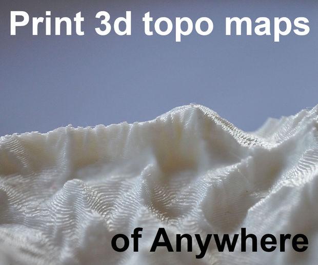
“By exploring that model you could experience the landscape as if you are a bird (or Superman) and able to fly around,” he says. “Standing in Yosemite valley looking up at Half Dome is amazing, but you only see it from one angle. The 3d model in the visitor center reveals so much more.”
When he started exploring 3D printing, he quickly discovered that there were plenty of resources for 3D printing his own maps – many of which, depending on available data, turned out to be more detailed than the ones he was used to seeing in visitors’ centers.
“For instance my model of Yosemite valley is so accurate that you can see individual trees,” he says.
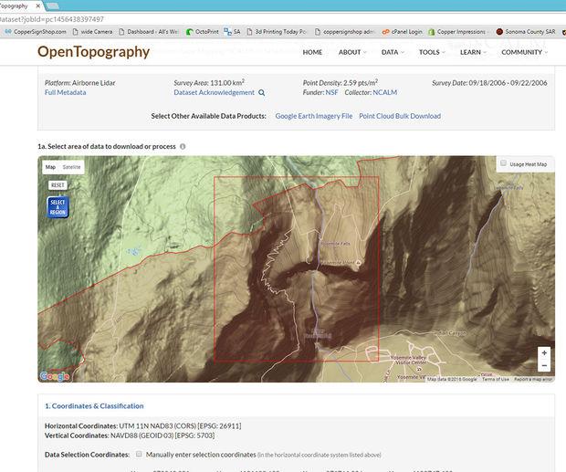
His first models were created using instructions from Swiss maker Gregor Lütolf, but he gradually modified them to perfect his own method, which he outlines in seven relatively simple steps on Instructables, beginning with the gathering of map data. While there are many online resources for obtaining digital elevation model (DEM) data, he suggests Open Topography, which has a vast collection of topographical data so detailed that trees and cars are visible in many cases. The site is also very easy to use – just select the area you want, play with the resolution if you like, and download it as a GeoTIFF file. Another site, if you strike out with Open Topography, is the National Map, though it’s limited to the US.
Once you’ve downloaded and unzipped your GeoTIFF file, you’ll need to convert it to an Ascii DEM file, which Potter recommends doing with either 3DEM or MICRODEM. From there, you can use your DEM file to create a 3D model; Potter suggests a program called AccuTrans3d, which you can download and try for free, though it’s $20 if you decide to use it. It’s worth it, according to Potter, who proceeds to give a quick rundown on how to use the software to easily convert your file to a 3D model and prepare it for printing.
Once that’s done, you’re almost there – you’ll just need to do a bit of tweaking.
“After you export your model from AccuTrans3d you may want to do some post processing before printing it. I usually use Blender to merge all of the polygons on the bottom of the model into one,” says Potter. “This cuts your model’s size in half with no loss of quality. It makes it easier on your slicer software particularly if your model is large to begin with.
“The other thing to consider is which orientation to print your model. For large scale things like mountains I tend to print them in real world orientation. This avoids printing overhangs and the layer lines mimic the topographic lines of a map which is cool. Really detailed maps made from LIDAR scans are sometimes better printed on their side because the sides of a print reproduce more detail than the top.”
Then it’s time to print. Potter advises using PLA and a build plate with good adhesion, as well as keeping your printer away from cold drafts – pretty standard 3D printing advice. His Yosemite model, he says, was comprised of 35 separate prints, each of which took about a day to print on a Replicator clone. Naturally, you don’t have to go that big, especially to start out, but there’s plenty of data out there to experiment with – you can try the sites Potter recommends, or find your own. Have fun exploring! Is this something you are interested in? Let’s discuss over in the 3D Printed Maps forum at 3DPB.com.

Subscribe to Our Email Newsletter
Stay up-to-date on all the latest news from the 3D printing industry and receive information and offers from third party vendors.
You May Also Like
3D Printing News Briefs, April 13, 2024: Robotics, Orthotics, & Hypersonics
In 3D Printing News Briefs today, we’re focusing first on robotics, as Carnegie Mellon University’s new Robotics Innovation Center will house several community outreach programs, and Ugogo3D is now working...
Rail Giant Alstom Saves $15M with 3D Printing Automation Software 3D Spark
3D Spark has entered into a three-year deal with the rail giant Alstom. Alstom, a transport behemoth with annual revenues of $16 billion, specializes in the manufacture of trains, trams,...
Meltio Expands Global Reach with New Partnerships in the Americas and Europe
Spanish 3D printing manufacturer Meltio has expanded its sales network across the globe. With the addition of three new partners in the United States, Brazil, Argentina, and Italy, Meltio aims...
3D Printing Webinar and Event Roundup: April 7, 2024
Webinars and events in the 3D printing industry are picking back up this week! Sea-Air-Space is coming to Maryland, and SAE International is sponsoring a 3D Systems webinar about 3D...